Tropical Storm Mekhala Changes Course, Forms New Tropical Depression
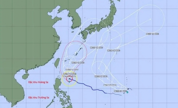
In the early hours of June 23, Tropical Storm Mekhala exhibited significant meteorological changes as it began shifting its trajectory northward, moving parallel along the eastern sea waters of the Philippines. According to meteorological forecasts, the storm system is expected to continue its path toward the island of Okinawa and southern Japan regions.
Current Status of Tropical Storm Mekhala
Tropical Storm Mekhala, one of the most powerful storm systems of this year's typhoon season, has demonstrated notable alterations in its movement pattern. Currently, the storm is predominantly active over the eastern Philippine Sea, with atmospheric models projecting its continued northward progression. Meteorological agencies have been closely monitoring these developments to provide timely warnings for potentially affected regions.
The storm has maintained its intensity as it progresses through the warm waters of the Pacific, where sea surface temperatures continue to fuel its development. Meteorologists report that Mekhala has exhibited characteristics typical of tropical cyclones forming in this region, with well-defined circulation patterns and organized convective activity.
Predicted Path and Timeline
| Date | Location | Direction | Status |
|---|---|---|---|
| June 23 | Eastern Philippine Sea | Northward | Active strengthening phase |
| June 24 | Okinawa region | Northward | Expected to intensify |
| June 25 | Southern Japan | Northward | Potentially impacting coastal areas |
| June 26-27 | East China Sea | Northwestward | Gradual weakening expected |
Meteorological Analysis
Atmospheric scientists have identified several key factors contributing to Mekhala's unusual path deviation. The interaction between the storm and a subtropical high-pressure system has caused the northward shift, a pattern that deviates from typical seasonal storm trajectories in the Western Pacific basin.
Sea surface temperatures in the region range from 28-30°C, providing optimal thermal energy for the storm's development. Additionally, vertical wind shear remains relatively low, allowing the storm to maintain its structure and intensity as it progresses northward.
Meteorological models indicate that Mekhala may undergo a slight intensification phase as it approaches the Okinawa region, before beginning a gradual weakening process as it encounters cooler sea surface temperatures and increased wind shear further north.
Potential Risks and Warnings
Weather experts caution that Tropical Storm Mekhala could bring heavy rainfall, strong winds, and high surf to areas near its center of circulation. The eastern Philippine coastal regions and the southern Japanese islands are particularly vulnerable to the storm's impacts.
Coastal areas may experience storm surges of 1-3 meters above normal tide levels, particularly in low-lying and exposed regions. Rainfall accumulations of 150-300mm are expected in some areas, potentially leading to flash flooding and landslides in mountainous regions.
The Japan Meteorological Agency has issued marine warnings for ships operating in the path of the storm, while the Philippine Atmospheric, Geophysical and Astronomical Services Administration (PAGASA) has placed several provinces under storm alerts.
Regional Impact Assessment
The potential impact of Mekhala varies across different regions:
| Region | Expected Impact | Risk Level |
|---|---|---|
| Eastern Philippines | Heavy rainfall, strong winds, rough seas | Moderate to High |
| Okinawa, Japan | Strong winds, heavy rain, possible flooding | High |
| Southern Japan | Heavy rainfall, coastal flooding, transportation disruptions | Moderate |
| East China Sea | Rough seas, strong winds | Low to Moderate |
Safety Measures and Recommendations
Authorities in potentially affected regions have implemented several preparedness measures:
- Evacuation orders for high-risk coastal areas
- Suspension of maritime activities and fishing operations
- Pre-positioning of emergency response teams and supplies
- Activation of emergency communication systems
- Public awareness campaigns through multiple media channels
Civil defense agencies recommend that residents in vulnerable areas secure outdoor objects, prepare emergency kits with essential supplies, and stay informed through official weather bulletins. Travel to and from affected regions should be avoided unless absolutely necessary.
Conclusion
The progression of Tropical Storm Mekhala continues to be monitored closely by meteorological agencies, with regular updates being provided as the storm develops. Residents in potentially affected areas are advised to remain vigilant and prepare for all eventualities in the coming days. Proactive disaster mitigation efforts will help minimize the potential damage and impact from this natural phenomenon.
As climate patterns continue to evolve, the frequency and intensity of such weather events may increase, highlighting the importance of robust early warning systems and community preparedness in disaster-prone regions.